 Rural Ontario's new management
tool Rural Ontario's new management
tool
Rural Ontario's new management
tool Rural Ontario's new management
toolDATAMAP Electronic Mapping introduces affordable off-the-shelf electronic maps of 120,000 Southern Ontario rural lots as polygons, ready to accept data. The data can be industry statistics, overlays of a seed producer's dealer/customer network, animal health or land use data, and any other figures and values on rural Ontario.
The true value of electronic mapping, emerging in the eyes of corporate managers, lies of course in the ability to integrate tabular data (addresses, values etc.) with geography (maps). Urban areas were the first to get their electronic maps. Rural agricultural areas had to wait for detailed polygonal boundary representation in large scale, before GIS (Geographic Information Systems) and Desktop Mapping can be used effectively. The basic land unit, the lot, had to be represented as an enclosed boundary or polygon, with which data can be associated and analyzed. Too large scale is impractical for picturing an entire county with its lots and concessions, as is a too small scale, if a sufficient level of detail is to be provided.
Now businesses and institutions can see the picture of their activities down to the farmer's field level. The physical location of a rural Ontario lot address can now be shown on a map. This will end the mystery of where on Earth is the actual location of a "R.R." (Rural Route) address. Prices depend on size and geographic features. Package price for all of Southern Ontario is substantially discounted. The maps are also available as Lot Centroid Points at 1/3 of the price of the complete file. A package with a Desktop Mapping software (MapInfo or others) with pre-installed Lot Polygon Maps is available from DATAMAP Electronic Mapping.
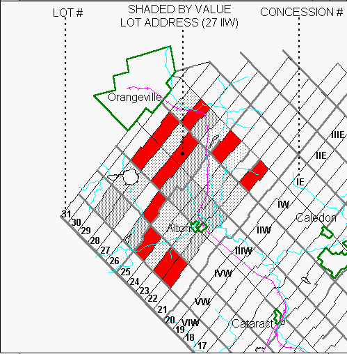
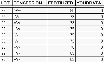
Following is an example of shading rural lots by value (fertilized acres), a tabular representation (database), and Legend:

Developed and produced by DATAMAP with the co-operation of the Ontario Ministry of Transport.
A CD with a sample area of the new maps can be obtained by calling (416)287-3240 or e-mail pblago@datamap.org
SEARCH QUICKER! enables you to automate large scale searches with MapInfo. The pointfile containing the centre points for each search is the CENTERFILE. The file containing the points to be searched is the SEARCHFILE. Both files must be geocoded. In the process of searching the program stores in a REPORTFILE records of the points find around each centre point within user-defined radius. Identification of the centre point is stored in the report. Automatic search is executed successively around every point of the CENTERFILE. A file containing centre points with zero finds is generated.
The program is available also for automated searches within boundaries, as SEARCH QUICKER! (BOUNDARY). Works like the program for radius searches
Price: $190
Available for MapInfo Professional
DATAMAP Electronic Mapping
HELPING MARKETERS SINCE 1976
56 Oakmeadow Blvd., Toronto, Ontario M1E 4G1
(416) 287-3240 Fax 287-3476
e-mail: pblago@datamap.org
Last updated February 14, 2014