Balkans 19th Century Ethnographic Maps
- The Ethnographic Map by Ami Boué (1847)
- The Ethnographic Map by Prof. Dejardin (1853)
- The Ethnographic Map by Lejean (1861)
- The Ethnographic Map by Hahn and Zach (1861)
- The Russian Ethnographic Map (1867)
- The Ethnographic Map by Mackensie and Irby (1867)
- The Ethnographic Map by Professor Erben (1868)
- The Ethnographic Map by Elisée Reclus (1876)
- The Ethnographic Map by Kiepert (1876)
- The Ethnographic Map by Synvet (1877)
- The Ethnographic Map by Sax (1877)
- South Eastern Europe Before the Ottoman Empire, (910-1210)
- Balkan Territorial Division According to the Berlin Treaty (1878)
- The Balkans After the 1912-1913 War Against Turkey
- Balkan Boundaries Drawn at the Treaty of Bucharest (1913)
1 Ethnographic Map by Ami Boué (1847)
Ami Boué (1794-1881) of French descent, is the first duly prepared man for scholarly research who explored the Balkan Peninsula in 1836-1838. His numerous works on European Turkey show clearly the careful way in which he investigated the countries visited by him. Among them the first place is due to his two principal works: La Turquie d'Europe, Paris 1840 (four thick volumes) and Requeul d'itineraires dans la Turqui d'Europe, Vienna 1854 (two volumes). His map is of extraordinary importance because of the extensive field studies made by the author. At first the map was added only to a few copies of the work; these were originals, coloured by Boué himself. Later on, the map appeared in the Physical Atlas by Berghaus.
Boué took special interest in the border areas between Serbia, Albania and Bulgaria (as shown on this map), which gives additional weight to his ethno-geographic record of the region. P. N. Miljukoff, who became the first Russian foreign minister after the revolution, one of the best contemporary authorities on Balkan Peninsula matters, had this comment on the true value of the map:
...The ethnographic map of the Balkan Peninsula drawn by him [Boué], and printed by Berghaus, is of great interest because it is the first ethnographic map that appeared before the tendentious disputes of the nationalities for possession of Macedonia have taken place. For this reason the map shows only that which the author had seen and heard on the spot, without any interpretations. The Slavic inhabitants of Macedonia are considered by A. Boué as Bulgarians, because they call themselves "B u g a r i". (see P. N. Miljukoff: "Five Ethnographical Maps of Macedonia with Text. St-Petersburg 1900")
2 Ethnographic Map by Prof. Dejardin (1853) This map is of Serbian origin. It bears the title Serbia and the Districts in which Serbian Language is spoken.. [etc.]. by Professor K. Dejardin. Belgrade 1853. Although its author bears a French name, he was one of the best-versed professors in the Serbia of his time. The author states that the map has been put together according to "Davidovich and other Serbian authors". As a matter of fact it represents the realm of the Serbian language just as the scholars of that time, who were not influenced by pro-Serbian politics.
It should be noted that Turkey left the Timok river basin to the Serbian Principality in 1833. Had this map been published before 1833, the Timok area would not have been added to the "by Serbians inhabited districts" and "in which the Serbian language is spoken". As it is evident from the history of Serbia, this area never belonged to Serbia, not even at Duschan's time when Serbia has reached the height of her power, nor even when the Serbian Patriarchat of Ipek existed. These facts are substantiated by Professor St. Stanojevich on the maps in his work History of the Serbian People, which has been officially accepted and used in all Serbian grammar schools. However, this remark is an objective one and should not be construed as applicable by analogy to the Kosovo ethnic problem situation, which is entirely different.
3 Ethnographic Map by Lejean (1861)
Guillaume Lejean (1828-1871) was one of the most studious and pluckiest French explorer-geographers. Twice he traveled in European Turkey (1857-1858 and 1867-1869), the last time in the quality of French Vice-Consul. The purpose of his enterprise, undertaken by order of the French Government, was to prepare a map of European Turkey.
4 Ethnographic Map by Hahn and Zach (1861)
From the book "Reise von Belgrad nach Saloniki" Von J. G. von Hahn, K. K. Konsul für das östliche Griechland. Wien 1861, mit 2 Karten.
This map is of special interest and value. First, it has been created as a result of an actual journey in the area by an an Austrian diplomat who has written a book on the area and its population. Second, individual villages are marked explicitly with A for Albanian, B for Bulgarian, S for Serbian and with a combination of these letters, implying mixed ethnicity. Each letter has been now represented by a corresponding color. The map is of particular value also because it has been perfected with the assistance of F. Zach, at that time director of the Serbian Military Academy, who thereby rendered the Serbian point of view most prominent; it can, therefore, be looked upon as an entirely Serbian map, more so because Serbian scholars and politicians of that time were fully satisfied by it. This appears from a letter, written by Jovan Gavrilovich and addressed to the well known folklorist and ethnographer Vuk Karadjich, the creator of the Serbian written language and orthography (see "Correspondence of Vuk Karadjich", Belgrade, 1907-1912, 6 volumes).
Von Hahn himself is known as an authority of Albania and the Western part of the Balkan Peninsula. His work "Albanische Studien" (3 Bände), his above mentioned book, as well as his work "Reise durch das Gebeit Drin und Wardar. Wien 1869" are studies of the highest value for historical knowledge of the peninsula. Von Hahn has accomplished his travels partly by order of the Vienna Government, partly by order of the Vienna Academy of Science. He seems to have known the ethnological conditions of the Balkans in his time thoroughly.
5 The Russian Ethnographic Map (1867)
In 1867 a "Slavic Exhibition" was organized in Moscow by the Russian Slavianofiles, with the participation of the most prominent exponents of Slavism. An ethnological map of all Slavic nationalities was prepared for the occasion, which made a great impression and was approved by the delegates. The map had such a success, that in the next 10 years it appeared in three editions. This map, historical because of its importance, was drawn by M. F. Mirkovich, the Russian geographer and ethnographer, and carried the title Ethnological Map of of the Slavic People. From the printed sheet relating to the map it appears that its author not only carefully consulted the ethnological literature of the Balkan Peninsula, but that he also collected information concerning certain districts directly from the best authorities.
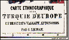
6 The Ethnographic Map by Mackensie and Irby (1867)
Two daring and well educated English ladies, Mackensie and Irby, traveled in the years 1862 and 1863 through a large part of the Balkan Peninsula and published their researches in 1867 in London in one big volume: The Turks, the Greeks and the Slavons. Travels in the Slavonic Provinces of Turkey-in-Europe. By G. Muir Mackensie and A. P. Irby, London, 1867. With Maps etc.
The authors devoted themselves to this work with great eagerness. Making inquiries everywhere directly from the local people, they collected information which they later verified with the consuls and the missionaries. Their conscientiousness and striving for objectivity went so far, as to verify anew the information at Constantinople, where they visited for that purpose the Greek Patriarchate and the representatives of the Bulgarian people in the capitol, whereby they also took into consideration the Greco-Bulgarian church quarrel occuring at that time and which ended in 1870 by the establishment of the Bulgarian Exarchate. The high value attributed to this book by competent readers is evident from the fact that it has been translated to several languages, and that a second English edition was published in 1877 with a preface by Gladstone, the British prime minister.
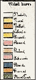
The map accompanying Mackensie and Irby's book and offered here is entitled Map of the South Slavonic Countries. A note found on the map reads:
The ethnological colours are taken from Frolich's Map of the Austrian Empire & Lejean's map of the Nationalities of Turkey in Europe, corrected here and there by an Engineer who traveled through Northern Albania, & by other persons acquainted with the country...
It remains unclear to what extent the map specifically reflects the labours of the authors of the book.
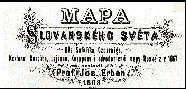
7 The Ethnographic Map by Professor Erben (1868)
The Czech writer, Jaromir Erben (1811-1870), was a scholar on Slavic languages, history and mythology, on which he has written valuable studies. His map Mapa Slovenskèho Sveta is not original. As Erben himself states in the map's subtitle, it has been drawn by him according to ethnological information given by seven different sources. The maps by Schafarik, Lejean, and the Russian map by Mirkovich (1867) have been most frequently made use of.
Erben's map appeared as a supplement to a Czech review on the Slavic nationalities in Europe.
8 The Ethnographic Map by Elisée Reclus (1876)
This map is from the principal work of the renowned French geographer Elisée Reclus (1830-1905) Nouvelle Géographie Universelle, which was published in Paris between 1875 and 1894 in 18 large volumes. It was richly furnished with maps and illustrations, and became a textbook for those interested in geographical matters. In France it was the first attempt to put geography on scientific footing.
Like Erben's map, this map also lists the sources for its compilation. It is valuable as a work of a well known geographer well versed in the literature on the subject, who has selected and compiled the sources (Lejean, Kanitz, de Czoernik) with good understanding of the problems in delineating the ethnic groups in the Balkans. Reclus's footnote at the bottom of the map reads: This map can only have a very approximate value. Most of the populations with their races and languages are interpenetrated and not juxtaposed.
As only a few cities are featured on the map the geographic reference is difficult, limited to physical features.
9 The Ethnographic Map by Kiepert (1876)
The fame attached to the name of the renowned German geographer and cartographer, Heinrich Kiepert (1818-1899), dates from the appearance of his distinguished Atlas von Hellas (1846). He afterwards published the excellent maps of Asia Minor and Palestine which he had worked out on the spot. These were followed by the well known at the time Bibel Atlas, of which three editions were issued in the course of eight years. The numerous maps drawn by Kiepert are all distinguished by scientific value and by previously unknown accuracy and craftsmanship. For his rare merits as a cartographer he received the "Grand Prix" at the Paris International Exhibition of 1867.
Kiepert undertook the exploration of the Ottoman Empire first in Asia Minor and then in Europe. During these scientific explorations he questioned the local inhabitants, in the mean time diligently studying the ethnological literature of the Balkan Peninsula. As a result of these researches and explorations the map corrects numerous errors of former ethnographic maps.
This map by Kiepert has the historical distinction of serving as a foundation for drawing the new Balkan political boundaries at the European Conference at Constantinople in 1876-1877, as well as in the Berlin Congress in 1878. Bismarck attributed high value to it.
10 The Ethnographic Map by Synvet (1877)
This map is a Greek one. It is drawn by the Frenchman A. Synvet, teacher of Geography at the Ottoman Lyceum in Constantinople; it is however put together according to the information provided by the Greek Patriarchate, and the Greeks have always considered it as a map of their own.
The coarse colored hatching used for thematic mapping of ethnicity distribution results in an exceedingly generalized rendition of Balkans' ethnical makeup.
The value of this map is in representing graphically the Greek view on the subject.
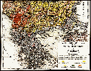
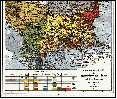
11 The Ethnographic Map by Sax (1877)
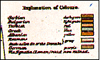
This Austrian map is the result of seventeen years of labour. Carl Sax had been a long time Austro-Hungarian Consul in Sarajevo, in Rustchuk (Russe), and in Adrianople (Odrin). He crossed European Turkey from end to end. Knowing the works and maps by Boué, Lejean, von Hahn, Kanitz, Kieper, Syvet and others, he collected field data which he checked against the information received from most Austro-Hungarian Consuls and Vice-Consuls of European Turkey. The results were published in a long series of important studies on the nationalities in the Balkans. Taking into account Sax's authoritative knowledge on the subject his map is of great importance. It was published as a brochure in 1878 by the Imperial and Royal Geographical Society in Vienna, whose competency we assume was of the highest order. Superior cartographic craftsmanship and clarity is supplemented by a superb detailed ethnographic categorization table functioning as a legend for the map.
The translated full title of the published brochure is: Ethnographic map of Turkey and her Dependencies at the time of the beginning of the War of 1877, by Karl Sax, I[mperial] and R[oyal] Austro-Hungarian Consul in Adrianople. Published by the Imperial and Royal Geographical Society, Vienna 1878. The title box of the map reads instead "...in the beginning of the year 1877" without mentioning the war. The following remark found in the brochure gives us an idea of the Society's evaluation of the map:
Besides the map by Consul Sax we also possess the sketch of an ethnographic map designed by Baron Karl von Kraus according to the best sources, in which the nationalities of the inhabitants of Turkey and their religious persuasions are taken into consideration, as Sax has done it also in his map. A close comparison shows the nearly complete agreement between the two maps and convinces us that the map by Consul Sax, a result of seventeen years of work on the actual locations, offers a cartographic picture of the ethnography of Turkey which is nearest to the facts.
In order to understand the full importance and commendable impartiality of this evaluation of Sax's map as a whole, one has to keep in mind that the map was published in 1878 and that at that time the official diplomacy of Austria, being afraid of Russia's expansive policy, fought openly for a separation of Macedonia from the newly created Principality of Bulgaria. But the map is free from any influence in this respect, showing the Bulgarian ethnicity of the population of Macedonia, without even mentioning the Macedonian dialect of the Bulgarian language in the elaborate table/legend. (This of course is not in compliance with the present day political reality).
12 South Eastern Europe Before the Ottoman Empire (910-1210)
Historical Maps by Prof. E. A. Freedman, Oxford University
Prof. Freedman's major work The Political Geography of Europe was first published in 1880, accompanied by an atlas. It reappeared in a 3rd edition after his death, edited by Prof. E. B. Bury of Cambridge University, an equally renowned historian.
This set of four small maps, as found in the 3rd edition of Prof. Freedman's atlas provide reference of a trusted source for comparing national boundaries in the Balkans today, with the boundaries in the centuries preceding the region's fall under a single ruler, the Ottoman Turks' Sultan. In the following period the numerous Balkan nationalities lived, moved and re-settled internally within one large common territory of a single administration for almost five centuries, unlike the rest of the European peoples. This was, and still is, the paramount factor for the persisting till modern times extraordinary interpenetration of nationalities and resilient ethnic groups in the region. The symptoms of lingering chronic "Balkanization" are a natural consequence of this factor, rather than a manifestation of some strange innate characteristics of the region's nations and people, as it is often implied.
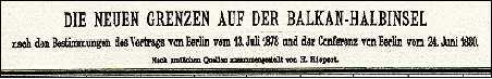
13 Balkan Territorial Division According to the Berlin Treaty (1878)
This map by Kiepert, the celebrated German cartographer, represents the Balkan Peninsula as divided by the Berlin Congress of June and July 1878 and by the special technical commission of the years 1879-80.
According to the treaty, signed in Berlin on the 13th of July, 1878, the newly created Principality of Bulgaria was cut into 5 parts, one of which, Macedonia, was given back to Turkey. The Berlin treaty is a convincing example of how international treaties should not be written. The wrong committed by this treaty has endangered the peace in Europe, and doubtless led to the Balkan wars, which led to the WW1 catastrophe. The dangerous strife in 1999 centered in Kosovo has much to do with what was done in 1878.
14 The Balkans After the 1912-1913 War Against Turkey
Pristina and the area of Kosovo are here part of a vast "Condominium", as the area was called at that time. This "Condominium", a territory common to all of the allies, Bulgaria, Greece, Montenegro and Serbia, was sanctioned by the treaty that ended the First Balkan War (1912-1913). The treaty was signed in London on May 30, 1913. The conference of the ambassadors, held later on in London, drew also the boundaries of Albania. The division of the common-to-all territory had to take place between Bulgaria and Serbia according to the treaty of alliance agreed upon, and between Greece and Bulgaria according to a previously signed agreement. Conspicuously missing from the historical records on the discussions at that time are the Albanian concerns about a substantial ethnic Albanian population in the short-lived "Condominium".
The dispute over the "Condominium" ended in eruption of hostilities, quite predictable in common-to-all land situations: The Second Balkan War of 1913 started – yet another war with democratic "moral cause" to end injustice.
15 Balkan Boundaries Drawn at the Treaty of Bucharest (1913)
The Bucharest Treaty sanctioned the second Balkan War in which Serbia, Montenegro, Greece, Romania and Turkey threw themselves on Bulgaria. The purpose of the attack was to take disputed territory previously under Turkish rule, including Macedonia, while dishonoring a Serbo-Bulgarian treaty of alliance, also a proposed by Greece in the spring of 1913 (Venizelos and Genadio, Greek Minister in London) Greco-Bulgarian frontier "along the line of the Chalkidika-Lakes" in exchange of Saloniki.
The treaty of Bucharest did not end the problem of "Condominium". It left vast national populations in an enforced explosive status quo.
DATAMAP Electronic Mapping
HELPING MARKETERS SINCE 1976
56 Oakmeadow Blvd., Toronto, Ontario M1E 4G1
(416) 287-3240
info@datamap.org
Revised: September 22, 2012. © DATAMAP Electronic Mapping. All Rights Reserved